The Hospital Fields
The Hospital Fields once stretched all the way down to the banks of the Liffey. The fields were used for grazing cattle and officers horses. Now referred to as The Meadow the open green space is used for music events, concerts and the local community as a green space for exercise and escaping from the concrete urban environment outside the walls.
The western Avenue runs a straight line from the Royal Hospital Building to the Western Gate and was the main ceremonial and coach entrance to the Hospital. It was developed shortly after the hospital was completed and cuts through the raised ground of the cemeteries at its western end. The fields to the south of the avenue were developed as the site car park between 1991 and 1995. The north side is bordered by the remnants of a ha-ha wall, a sunken wall to prevent livestock escaping the fields, but it was also designed to make sure the view of the landscape was not interrupted by a wall. They were named in the Georgian period as people would shout “ha-ha” in surprise as they accidentally fell into them.
The further west we travel through the grounds of IMMA the further we go back in time. The area to the west end of the meadow and the cemeteries has been revealed, through non-invasive surveys, to have been the location of the Priory of the knights Hospitaller. In 1172 the order of Crusading Knights were given the lands of Kilmainham after the Norman invasion and constructed a large defensive military complex to protect Dublin city from attack from the west. The Hospitallers were formed after the first crusade of 1069. They principally cared for the wellbeing of Christian pilgrims and protected them on their journey to the Holyland. Though their main interest in Ireland was to acquire land and raise funds to support their crusading function in the near east, the Knights Hospitaller became critical in the Rule of the English crown in Ireland until the dissolution of the Monasteries by Henry the VIII in 1541. The Prior of the order held a seat on the Irish Privy Council and on several occasions acted as the Lord Justiciar or Lord Deputy, representing the English king in Ireland. The order still exists today as the Sovereign Order of Malta and the Venerable Order of St John.

Between 2021 and 2022 IMMA, the OPW and Dublin City Council Archaeology developed an illustration project with Illustrator Stephen Conlin to reconstruct the landscape of Kilmainham when the Hospitaller Priory was at the peak of its power in 1340. All evidence points to the priory having occupied the western end of the meadow and a large part of the burial grounds and the area to the north where the railway culvert was excavated in the 1840’s. The Subject Matter Experts that contributed to the project included:
Ruth Johnson, City Archaeologist DCC (Client); Niall Colfer Assistant City Archaeologist; Barry Kehoe, IMMA (Client/Project Partner); Mark Hennessy, OPW (Client/Project Partner); Grace McMahon, OPW (Client/Project partner); Tadgh O’Keefe, UCD Archaeology (Lead Subject Matter Expert); Paolo Virtuani, UCD History; Linzi Simpson, Ind. Archaeologist; Frank Cullen, Irish Historic Towns Atlas (IHTA); Raghnall O’Floinn, National Museum Rtd.; Barney Sloane, Historic England; Edel Bhreathnach, Discovery Prog Rtd.; John O’Keefe, CEO Discovery Prog; Howard Clarke, IHTA.

In the south West Corner of the meadow a geophysical survey in 2012 revealed an anomaly with the footprint of a 12th century church built on an older ecclesiastic site, an orthogonal structure surrounded by a series of concentric ditches. This could possibly be the parish Church of St. John and the site St Maighneann’s oratory.
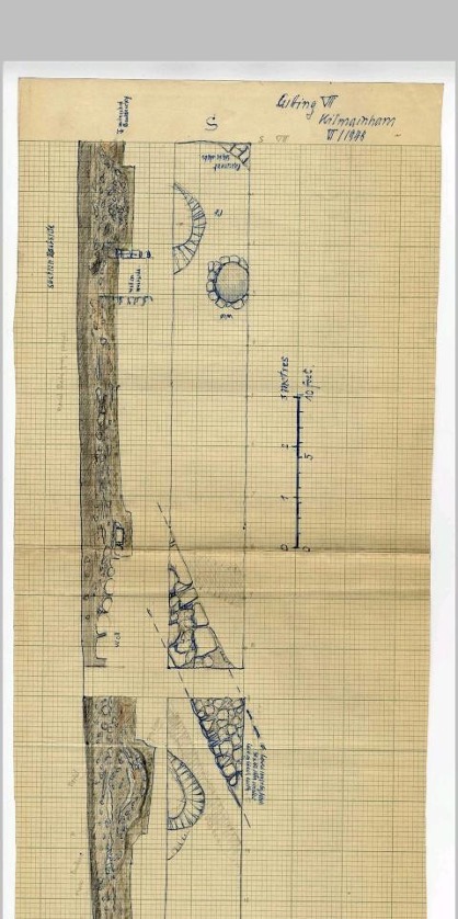
In 1948 Gerhard Bersu was invited to excavate the meadow in search of traces of Viking habitation. He only found archaeology connected to the late medieval period, more than likely traces of the Hospitaller Priory or the Church of St John.
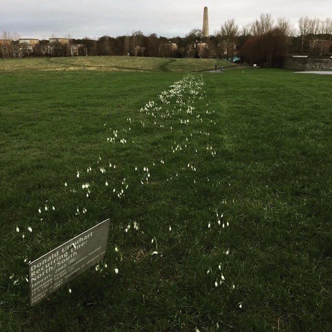
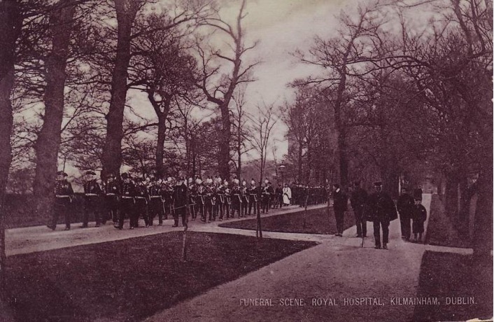
Kilmain has been a site for mustering armies to besiege Dublin during the Viking and norman periods. Brian Boru camped here on the eve of the battleof Clontarf in 1014. The Meadow continues to be a site of gathering today for more pleasant activities such as rock concerts and festivals but it also is an inspiring site for outdoor artworks like Donald Urquart’s Recurring Line.
SUPPORTED BY
The IMMA Heritage Trail is kindly supported by An Chomhairle Oidhreachta / The Heritage Council and the Office of Public Works. OSI Historic map details are provided courtesy of Tailte Éireann.


