Bully’s Acre
Bully’s Acre presents one of the most fascinating locations on the IMMA campus. It became part of the lands of the Royal Hospital under the charter of King Charles II, but by 1680 the area that adjoined the Common Green of Old Kilmainham village, now the site of Kilmainham Gaol, had become widely used as a burial ground. After the dissolution of the monasteries the land where the Knights Hospitaller Priory once stood, evolved into the main graveyard for Dublin city. It is possible that a small cemetery associated with the Priory or Parish Church of St. John eventually spread out across the entire hill terrace of Kilmainham. [Historic Maps, OSi]
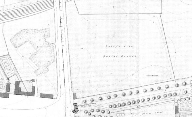
The cemetery was used largely as a paupers and catholic cemetery during the penal laws, but not exclusively, as wealthier families commemorated their loved ones with headstones. Most grave markers would have been made of wood and have long since vanished. The name Bully’s Acre only came into popular use in the 19th century, the previous title for the area was the field of the Priory of St John as noted in the minutes of the board of Governors of the Royal Hospital.
The cemetery area had been used by the local population for burials for several generations before the fields were granted to the Royal Hospital. This resulted in the land and its use being contested from the earliest days of the Royal hospital, with several attempts to close the ground and stop the burials. In 1707, 1737. 1755 and 1795 walls were built to enclose the burial ground with only the 1795 wall remaining untouched. In 1755 Master of the Royal Hospital Michael O’Brien Dilkes attempted to stop burials and public movement through the Royal Hospital grounds. Dilkes walled off the cemetery, levelled the ground, buried all the head stones and limed the soil. This is why no headstone predates 1764. but he lost a battle in the courts over a right of way throught the Royal Hospital Fields and an angry mob, on hearing the result, marched to Kilmainham and tore down the walls.
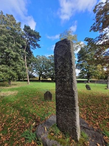
Master Dilkes also buried the oldest monument on site a 9th-11th century standing stone. There is also conjecture that the standing stone is the remnants of a high cross shaft. The standing stone was rediscovered by John Trial and resurrected in 1795. It was probably moved from its original location at that time. Local legend has it that the grandson of Brian Boru was buried near the high cross of Kilmainham after the battle of Clontarf in 1014. The cemetery closed in 1832 after a cholera epidemic that saw nearly 6000 people buried there in the space of a month.
Bully’s Acre is the site of most interest when we look for the site of St Maighneann’s monastery, whose church gave the area of Kilmainham its name. The Monastic settlement controlled a river ford that crossed the Liffey somewhere near Islandbridge. The Liffey in the 7th century was the border between the kingdom of Laighean to the south and the Kingdom of and Breá to the north. The settlement was at that time more important and larger than Atha Cliath, further downstream, where the city of Dublin would later develop. Maighneann was a prince of Airgíalla, a kingdom that included the ecclesiastic centre of Armagh. His presence at this important border crossing shows the complex political nature of his position and his familial relationship that probably bound the kingdoms of Laighean and Airgíalla together in a dynastic alliance.
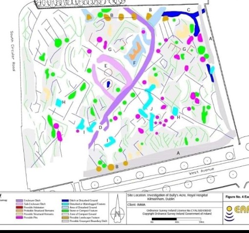
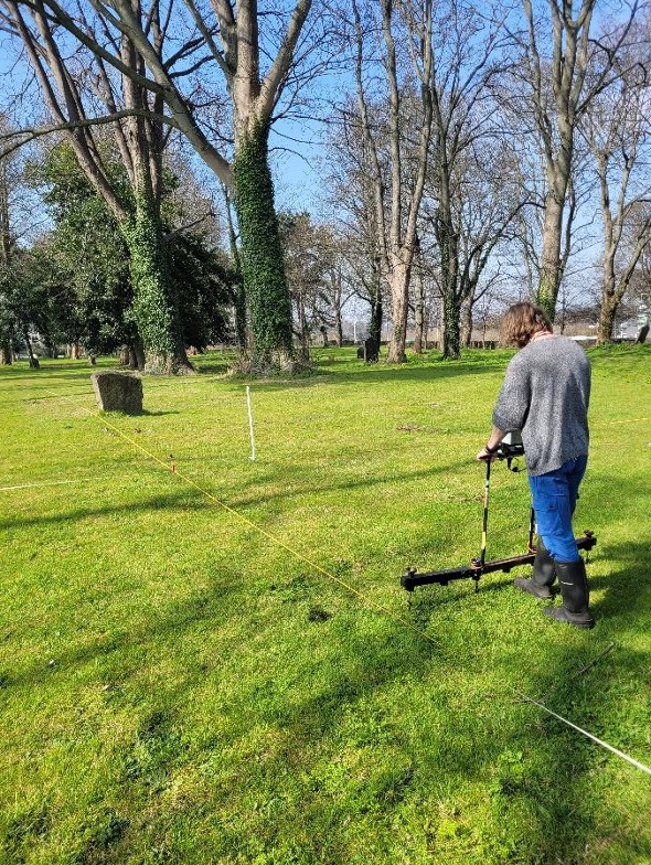
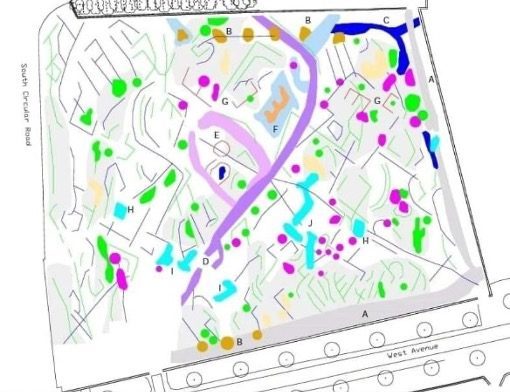
In 2022 a Geophysical Survey of the cemetery revealed enclosure ditches and sub enclosures that could relate to the monastic settlement. These features have yet to be truth tested but they give us some hope that remnants of the earliest known settlement in Kilmainham still exist in the site Archaeology. In early maps there is also a curvilinear ditch on the west side of the cemetery and Royal hospital grounds. This was removed in 1775 when the road was straightened to develop the south circular road.
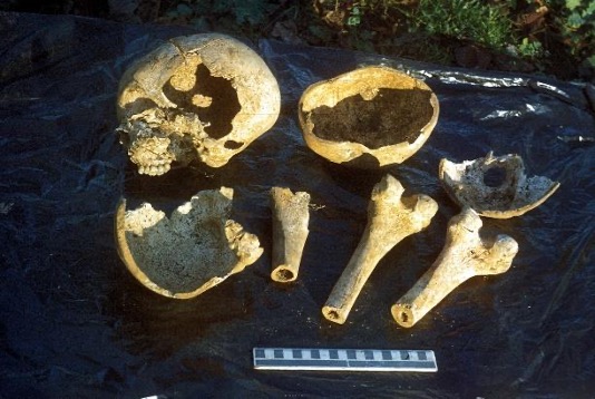
The only known archaeological dig of the cemetery took place in 1991 during road widening when Paddy Healy excavated a narrow section along the south circular road. He uncovered remnants of the Hospital Priory as demolition rubble in a medieval fosse. He also found disarticulated human remains with evidence of postmortem dissection, which is of no surprise, as the cemetery was a notorious location for bodysnatching. There was also evidence of mass graves from the time of the cholera epidemic that finally closed the burial ground.
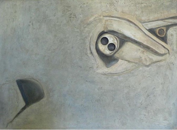
Our contemporary fascination with the past and the traces of lost time persist through the artistic output of our present times. The works by artist Maira Simonds-Gooding in the IMMA Collection are inspired by the ancient marks and traces of old tumuli, raths and ringforts in the Irish Landscape.
SUPPORTED BY
The IMMA Heritage Trail is kindly supported by An Chomhairle Oidhreachta / The Heritage Council and the Office of Public Works. OSI Historic map details are provided courtesy of Tailte Éireann.


